- About the zoning code
- Zoning code descriptions
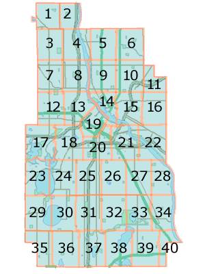
- Zoning Districts: Plate 01
- Zoning Districts: Plate 02
- Zoning Districts: Plate 03
- Zoning Districts: Plate 04
- Zoning Districts: Plate 05
- Zoning Districts: Plate 06
- Zoning Districts: Plate 07
- Zoning Districts: Plate 08
- Zoning Districts: Plate 09
- Zoning Districts: Plate 10
- Zoning Districts: Plate 11
- Zoning Districts: Plate 12
Zoning maps
You can view zoning maps and determine the zoning classification of a property.
Explore this section
- Zoning Districts: Plate 13
- Zoning Districts: Plate 14
- Zoning Districts: Plate 15
- Zoning Districts: Plate 16
- Zoning Districts: Plate 17
- Zoning Districts: Plate 18
- Zoning Districts: Plate 19
- Zoning Districts: Plate 20
- Zoning Districts: Plate 21
- Zoning Districts: Plate 22
- Zoning Districts: Plate 23
- Zoning Districts: Plate 24
- Zoning Districts: Plate 25
- Zoning Districts: Plate 26
- Zoning Districts: Plate 27
- Zoning Districts: Plate 28
- Zoning Districts: Plate 29
- Zoning Districts: Plate 30
- Zoning Districts: Plate 31
- Zoning Districts: Plate 32
- Zoning Districts: Plate 33
- Zoning Districts: Plate 34
- Zoning Districts: Plate 35
- Zoning Districts: Plate 36
- Zoning Districts: Plate 37
- Zoning Districts: Plate 38
- Zoning Districts: Plate 39
- Zoning Districts: Plate 40
Find zoning classification
How to find a zoning classification
- Select a zoning plate.
- Determine your primary and overlay district classifications.
- Use the zoning map
- For more information, see the Minneapolis Code of Ordinances.
See Minneapolis Code of Ordinances
About the zoning map
- The GIS application provides a visual display of zoning information for your convenience.
- The official Zoning Map is a living document constantly updated to keep up with amendments.
- Every reasonable effort has been made to assure the accuracy of the maps and associated data.
- The City of Minneapolis assumes no legal responsibility for the accuracy of this map.
- For illustrative purposes only. Zoom in to see all the zoning areas.
- Click anywhere on for more information about the zoning districts.
Contact us
Zoning Administration
Community Planning & Economic Development
Phone
Call 311 or (612) 673-3000
Fax: 612-673-2526 and TTY: 612-263-6850
Address
Public Service Building
505 Fourth Ave. S., Room 320
Minneapolis, MN 55415